The population of the Latrobe Valley has undergone a remarkable transformation in recent years. Throughout the 1990s, the main story was one of decline, but today the picture is completely different. What factors are behind this turnaround?

Releases of population data by the ABS inevitably focus media attention on the rapidity of growth in our capital cities and the pressure this places on infrastructure and services as in this article published in The Age “City’s Population Explosion”. While this focus is not unwarranted, it does tend to overlook population trends occurring in the rest of the country.
Latrobe Valley in the 1990s
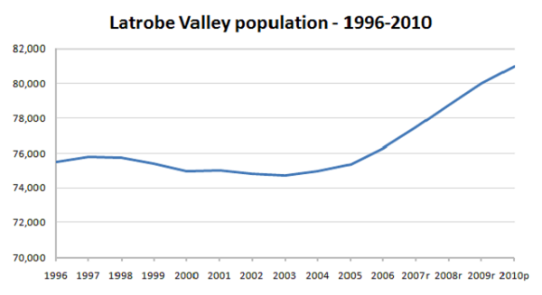
One of the more interesting population trends revealed in the ABS’s recent release of Regional Population Growth Australia (Cat. No. 3218.0) is the population turnaround that has occurred in the Latrobe Valley in eastern Victoria in the last five years or so. The fortunes of this region and the economic restructuring that occurred as a result of the privatisation of the State Electricity Commission (SEC) in the 1990s are well documented. The resulting job losses and out migration had an immediate impact on the population and the towns of the valley. In 1991, the ERP of the Latrobe Valley SSD was 79,450, but this had declined to 75,467 by 1996. A lack of alternative employment options and resulting increases in unemployment compounded social disadvantage in the region. Living in the “Valley” had a stigma attached to it and in the late 1990s it seemed that downward pressures on population would continue into the foreseeable future.
Urban settlement pattern
The urban settlement pattern in the Latrobe Valley is somewhat unique in that there are three large towns (Traralgon, Moe and Morwell) located within a 35 km stretch of the Princes Freeway. Though they are separate towns in their own right, together they have a population approaching 50,000. In terms of Australia’s urban heirarchy, this represents a critical mass which is crucial for service and infrastructure provision.
The peaks and troughs
The chart below shows the ERP of the Latrobe Valley SSD from 1996 to 2010. Clearly, population levels were stable or declining in the period from 1996 to about 2004. Since 2005, the population has increased by over 5,600, or 1.5% per annum. In 2009, the population had surpassed its 1991 level (ie pre-SEC privatisation) and in 2010 was estimated to be just over 81,000.

Traralgon is the growth hot spot
Population growth has not been even across the Valley. Traralgon is the growth hotspot, capturing almost two-thirds of population growth between 2005 and 2010. Even in the late 1990s, when other parts of the Latrobe Valley were losing population, Traralgon still recorded some growth. But in contrast to that time, growth is far more rapid, and Traralgon is now a bustling town with a thriving retail heart and an increasingly diverse economic base. New housing estates on the northern edge of town have developed rapidly, extending the urban area into the surrounding countryside.
So why has the Valley’s population turned around?
- Despite the economic restructuring of the 1990s, the region is still a key player in the generation of electricity for the state of Victoria. Utilities and mining are key industries – they may not have the number of jobs they once did, but they are still significant in terms of economic output. This in itself creates a momentum for economic investment and job creation in other sectors of the economy.
- The economic base of the region has diversified and shifted towards services. Since 1996 unemployment has declined and there has been strong growth in retail trade and health and community services. Key services such as the Latrobe Regional Hospital are dependent on the critical mass of population that exists in the Latrobe Valley and also create demand for other services.
- Continuing improvements to transport infrastructure increasingly draw the region into Melbourne’s economic catchment. The opening of the Pakenham Bypass and the extension of freeway conditions beyond Morwell shorten distances, paving the way for the growth of freight traffic, economic investment and commuting. Latrobe City’s community profile shows a small proportion of residents commute to Melbourne and neighbouring Baw Baw Shire for work.
- The Latrobe Valley is not all about its major towns. Though the Callignee region was devastated by the Black Saturday bushfires, the foothills of the Strzelecki Ranges, particularly around Boolarra, are a popular tree change destination. Smaller towns such as Trafalgar and Churchill offer affordable housing options for young families.
What does the future hold?
The Latrobe City population forecasts prepared by .id in 2010 suggest that this growth will continue. The population of Latrobe City is forecast to reach 90,710 by 2031. Continuing economic investment, development of clean coal technologies and transport improvements such as the imminent construction of the Traralgon Bypass augur well for the future of this region. To learn more about the future of Latrobe City, .id’s detailed population forecasts are available for public viewing here. Population forecasts for other areas of Australia are also available from .id’s website.
If you enjoyed this article, sign up to get updates via email or twitter (above), and feel free to share it.


