What is a peri-urban area and how are they changing?
At .id, we often blog about population growth and change across metropolitan areas of Australia because let’s face it – the current era of rapid population growth is changing our demographic story and creates significant urban planning challenges. But what of those people who live beyond the urban fringe in semi-rural areas – the so-called ‘peri-urban’ regions? Let’s take a look at what we mean by peri-urban areas and delve into the main demographic trends affecting these areas.
How do you define peri-urban?
This is the proverbial $64,000 question. In general, the term refers to areas beyond the metropolitan fringe, at the interface between city and country but within the economic and social catchment of a large metropolitan area. Several authors have tried to simplify the definition by describing peri-urban areas as “areas on the urban periphery into which cities expand” or “which cities influence” (Buxton, 2011, p2).
It can be difficult defining a peri-urban area using Local Government Area (LGA) geography because many of these areas contain a variety of land uses. Metropolitan areas across Australia have different relationships with their peri-urban areas depending on size, history, economic relationship and topography. Many councils in these areas belong to organisations such as the Peri Urban Group of Rural Councils.
For the purposes of this blog, I’ve selected LGAs at or beyond the urban fringe, but with which there is a significant economic relationship, as can be demonstrated by commuting trends. To distinguish between LGAs that have suburban growth as a result of being located on the urban fringe, LGA geography is further split into “outer urban” and “peri-urban”. This provides 38 LGAs in Australia that can be defined as peri-urban, 10 of which are outer urban (particularly in WA).
Population growth and change in Australian peri-urban areas
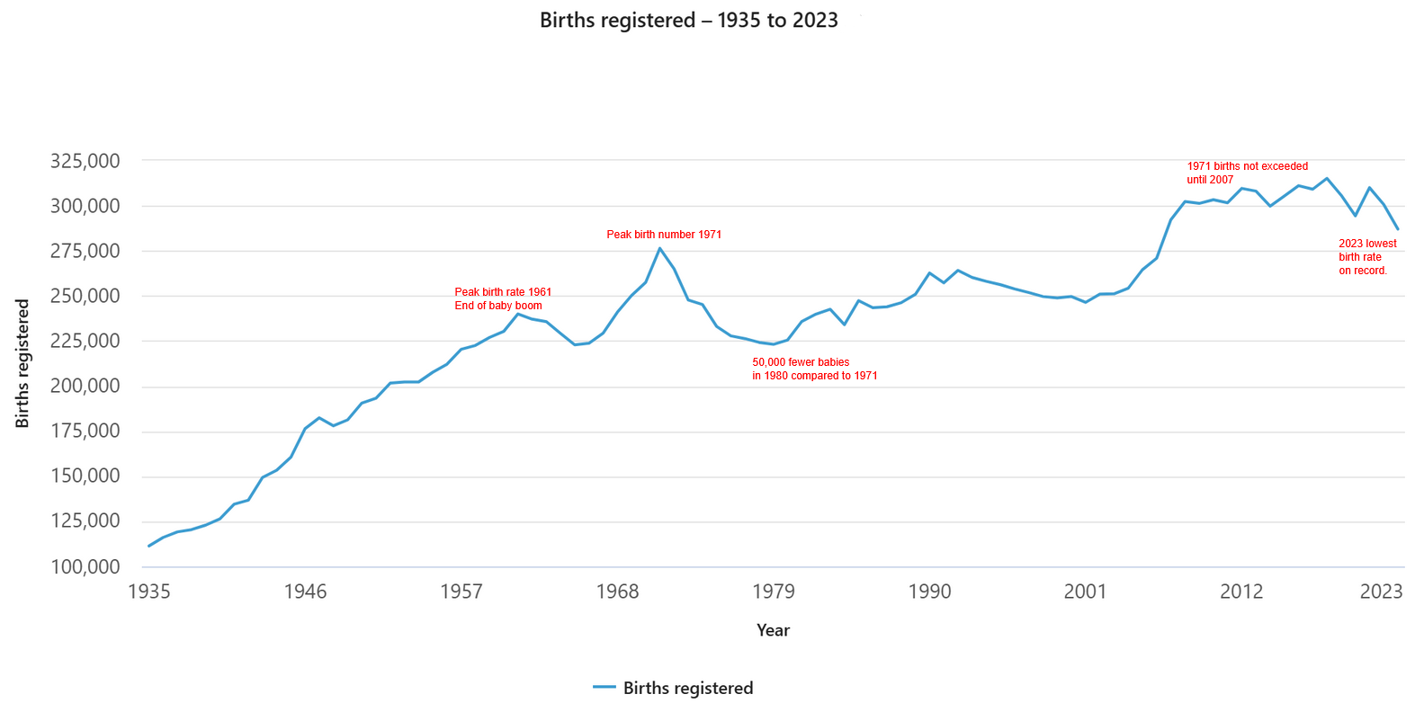
In total, there were 1,85 million people living in peri-urban regions in 2016, an 18% increase of 1.57 million on the 2006 figure. Over the ten years, this represented growth of 285,255 persons or 1.7% per annum. This is on a par with the growth rate for Australia over the same period but is less than that of the state capitals (2.0% per annum). The table below shows the population and rate of change in Australia’s peri-urban regions between 2006 and 2016.
Population growth in peri-urban regions, 2006-2016
Source: ABS, Regional Population Growth (ABS Cat. no. 3218.0)
* the peri-urban areas of the ACT are located in NSW and include Queanbeyan-Palerang and Yass Valley
State-based peri-urban patterns
Growth rates varied considerably between States. Population growth was slightly faster in outer urban LGAs (1.9% per annum) compared to 1.5% in peri-urban LGAs. Much of this is due to the inclusion of fast growing outer suburban LGAs in Western Australia such as Armadale and Serpentine-Jarrahdale but these also include wide tracts of peri-urban areas in the Perth hills. It is an example of how differing settlement patterns and LGA structures create difficulties in defining peri-urban areas using standard geographies but at the same time provides a starting point for discussion.
The peri-urban area in the Northern Territory recorded the most rapid growth rate between 2006-16, at 4.4% per annum. There is only one LGA in this area – Litchfield Municipality – which covers a wide area including some of Darwin’s semi-rural areas such as Howard Springs and Humpty Doo. The population increased from 16,451 in 2006 to 25,262 in 2016 and there a dispersed settlement pattern based on large lot rural residential living. This offers opportunities for semi-rural living but still within commuting distance from the state capital – perhaps the quintessential peri-urban draw card.
Other peri-urban areas recording above average growth rates were Western Australia (2.6% per annum), Victoria (2.3%) and Queensland (2.2%). Peri-urban LGAs in WA are small in population and include Chittering, Gin Gin and Toodyay to the north of Perth, and Murray to the south. Of these, the Shire of Chittering recorded the most rapid growth, averaging 4.2% per annum between 2006-16. Like Litchfield, Chittering also offers large lot rural residential opportunities within commuting distance from a major metropolitan area. Notably, the Shire of Toodyay recorded very modest population growth between 2006-16 and even lost population (-0.1% per annum) between 2011-16. Although some parts of the Shire, such as Morangup, are closer to Perth and have a rural residential settlement pattern, it also extends into agricultural areas where the population declined between 2011-16. Again, this highlights the diversity of peri-urban areas and why it can be difficult to define it using LGAs.
Victoria’s peri-urban LGAs generally recorded strong growth, with the exception of Murrundindi Shire. This LGA bore the brunt of the 2009 Black Saturday bushfires and the resulting loss of property, coupled with significant out migration, led to population loss between 2006-11. The population has since grown but when taken over a 10-year average, the growth rate was just 0.2% per annum. The fastest growing peri-urban LGA in Victoria was Mitchell Shire, which grew by 3.1% per annum between 2006-16. The southern parts of Mitchell are within commuting distance to Melbourne, particularly the northern suburbs, and in recent years there has been significant growth around Beveridge, Wallan and Kilmore. Mitchell LGA is earmarked for significant growth in the future and will eventually become part of Melbourne as development occurs along the Hume Freeway to create a continuous metropolitan area.
Queensland’s peri-urban areas all recorded strong growth, ranging from 1.8% per annum in Scenic Rim to 2.5% per annum in Somerset Regional Council. The settlement pattern in Somerset is dispersed but skewed towards the southern part, where there are a number of smaller towns that have good transport links into Brisbane and Ipswich in particular. This means it is attractive to those seeking a semi-rural lifestyle within commuting distance of a state capital. Scenic Rim also has a dispersed settlement pattern with one mid-sized centre (Beaudesert) but is well located with respect to commuting into Brisbane and the Gold Coast.
In contrast, population growth in outer urban and peri-urban LGAs in NSW was below the national average. Hawkesbury City represents an outer urban LGA and grew by 0.7% per annum between 2006-16. Despite its location on the north western urban fringe, Hawkesbury has a long history of modest but steady population growth. Richmond and Windsor are historic towns with some growth in the former. However, most of the settlement pattern in the City is based around agriculture and large lot rural residential, and much of the north and west is covered by national parks which constrain urban development. The pattern of growth in peri-urban councils varied considerably, ranging from 0.4% per annum in Blue Mountains City Council to 2.0% per annum in Wollondilly. Residential development in the Blue Mountains is naturally constrained by topography and national parks and like Hawkesbury, there is a long history of modest but steady growth. In contrast, Wollondilly has recorded more rapid growth on the back of new housing estates around Appin and Wilton. Significant growth is forecast to occur in the future, particularly as development opportunities in Camden and Campbelltown become exhausted.
Understanding patterns of change
Patterns of population growth and change in peri-urban areas are quite diverse and driven by several factors which may operate differently depending upon an LGA’s distance, opportunities for residential development and the strength of commuting links. These patterns create particular planning challenges in peri-urban areas but as ever, a sound evidence base upon which to make decisions is half the battle.
For a more in depth understanding of the demographic patterns affecting peri-urban areas, selecting more localised geography is likely to provide deeper insight. Viewing the information spatially also reveals visual patterns that can often be hidden in the data, adding an important element of place-based perspective to any analysis and planning. But that sounds like a blog for another day.
Do you work or live in a peri-urban area? Or face particular challenges planning for the development or provision of services in peri-urban areas? The .id community suite of information tools is currently being updated with information from the 2016 Australian Census for LGAs across Australia, providing a wealth of up-to-date knowledge about peri-urban areas. To help you answer more advanced planning challenges in peri-urban areas, .id’s team of population experts are always on hand to work with you to understand the questions you need to answer and provide the evidence base required to inform confident decision making.

.id are population experts who analyse, enhance and present Census data using demographic web tools and through consulting services. You can access our free community population profiles online to see how the results from 2016 Australian Census relate to your local area.
Simone - Myth Buster
Simone has a rich background in human geography, demography and urban planning – a background that was useful in her previous roles in the Commonwealth and State Governments, and now as part of the forecast team at .id. From the Queensland coast to the southern suburbs of Perth, Simone produces population and dwelling forecasts that help local governments make informed decisions about future service and planning needs. She is a regular contributor to .id’s blog and has spoken at several conferences on how our cities and regions are changing. She is a big advocate of evidence-based planning and how Census and other data can inform this. Outside of work Simone is a keen traveller and photographer – interests that tie in well with her professional life and help her to understand “place”.