We are proud to announce the completion of our latest set of population forecasts for the entire state of Western Australia. This was no small task! With around 3000 small geographic areas across the state, our SAFi forecasts provide the most detailed population data available and support a wide range of strategic planning decisions.
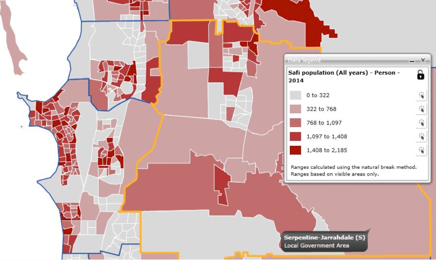
1 Total population, Southern Perth area, 2014

Highlights – how is Western Australia’s population changing?
Some of the more interesting findings that emerge from the population forecasts include:
- Western Australia is expected to continue its reign as the fastest growing state.
- The population of Greater Perth is projected to increase from 1.83 million in 2011 to 2.35 million in 2021. This increase represents 82 per cent of the total population increase for Western Australia.
- A slowdown in mining projects is likely to see more pressure on the labour force and unemployment may rise. As a result, we have factored in a lower share of overseas migration to WA. We expect a net addition of 32K in the medium to long term, and a slowdown in the interstate migration gain (2K) in the future.
- An expected slowing of population growth over the forecast period, slowing progressively from an average annual of 2.7% in the 5-years ending 2016 to 1.5% in 2036.
- Wanneroo is expected to lead residential development with an average of 3,100 additional dwellings each year. Within Wanneroo development will be concentrated in Tamala Park, Alkimos, and Eglinton and around Wanneroo township.
- The rapid growth in Pilbara-Kimberley is expected to slow considerably over the next 3-years.
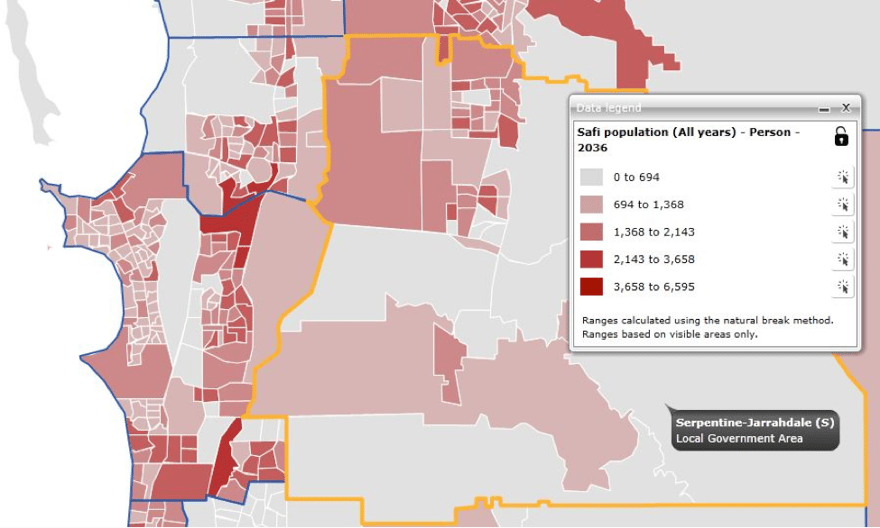
- Serpentine-Jarrahdale is expected to retain the fastest population growth in Perth, averaging 4.8% p.a. between 2014-36.
2 Total population, Southern Perth area, 2036

Some of these findings will be explored in future blogs as well as a forthcoming e-book.
About SAFi (Small Area Forecast information)
.id has been working to extend its detailed small area population and household forecasts beyond Victoria, New South Wales and the ACT. With the completion of Western Australian small area forecasts coverage has reached just under 70% of the Australian population as at 2014. We intend to extend this coverage over time, while ‘keeping the plates spinning’ with regular scheduled updates to the existing states and territories to maintain their currency.
SAFi (small area forecast information) forecasts independently model population futures from both a tops-down and bottoms-up perspective. Note, as these forecasts are produced with a different methodology to those undertaken for local government under our forecast.id banner, results may vary.
.id has been producing detailed small area population and household forecasts on a regular basis (18-24 month cycles) for Victoria over the last five years. Data for New South Wales and the ACT has been available since mid-2012. The first release of Western Australian state-wide forecast data was completed mid- 2014.
A detailed methodology paper is available on request.
How are the SAFi forecasts used?
The strength of SAFi is its geographic flexibility, whereby it is possible to combine the small area forecasts to create user-defined catchments and areas that do not conform to administrative boundaries. Organisations like the Catholic Education Office use SAFi to forecast demand for Catholic schooling across their parishes. The Victorian Electoral Commission use them to establish electoral boundaries with equal population distribution. You can learn more about SAFi here.
.id is a team of population experts, who use a unique combination of online tools and consulting to help organisations decide where and when to locate their facilities and services, to meet the needs of changing populations. Access our free demographic resources here.
Read more in our new eBook, Western Australia: Is it all doom and gloom after the boom?


.png)


