The Fleurieu Peninsula is located south of Adelaide, separated from the state capital by the southern Mount Lofty Ranges. Australia’s longest river, the Murray, ends its journey here. Traditionally, the Fleurieu Peninsula has played a role as a holiday and retirement destination, but towns in the north are increasingly becoming part of Adelaide’s commuting belt. With the recent addition of Victor Harbor to the .id community (view profile page here), we now have online profiles for the three municipalities that make up the Fleurieu Peninsula in South Australia (the other two are Yankalilla and Alexandrina). What are the characteristics of this interesting part of South Australia?

Population growth and change
South Australia consistently records below average population growth, but the same cannot be said of the Fleurieu Peninsula. In contrast to state-wide trends, it is a region characterised by strong population growth. In 2010, the Estimated Resident Population of the Fleurieu Peninsula was 42,500, an increase of 2.7% on 2009. This compares with a figure of 1.2% for South Australia. Alexandrina (3.0%) and Victor Harbor (2.6%) were amongst the fastest growing municipalities in South Australia in 2009-2010 – in fact, the only LGA that grew faster was the outer northern Adelaide municipality of Playford, which also grew by 3.0%. This relatively rapid growth poses significant planning challenges for a region with a small population base.
These of course are official population estimates, but due to its role as a holiday destination, the population of the region swells significantly in the summer months. Some estimates suggest Victor Harbor’s population trebles at this time of year, placing additional pressures on services and infrastructure.
Settlement pattern
Though the region is largely rural, there are a number of historical towns along the southern coastline of the Peninsula which have since grown to the extent that urban development is virtually contiguous from Goolwa in the east to Victor Harbor, some 25km to the west. In so far as townships go, Victor Harbor is the largest of these, with a 2006 Census population of 10,379. There are a number of small towns located along the many waterways in the region, such as Cape Jervis (where you catch the ferry over to Kangaroo Island), Normanville (on the west coast), historic Port Elliot (southern coastline) and Milang (Lake Alexandrina). Aside from this, much of the Peninsula is rural in nature, with the only other major settlements being Strathalbyn and Mount Compass in the northern part of Alexandrina Shire. These towns have grown rapidly in recent years as they are increasingly becoming part of Adelaide’s commuting belt. There are new housing estates on the fringes of both towns and the influx of new residents, primarily families, is changing the demographic mix of the region.
Age structure
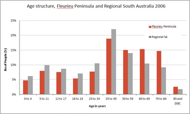
The Fleurieu Peninsula has an older age structure when compared to Regional South Australia (see graph below). Victor Harbor in particular has an elderly profile, with almost one-quarter of the population aged 70 years and over. This reflects the large in flows of retirees to the region who then typically stay for the remainder of their lives. Though many retirees purchase properties or move into their holiday homes, there have been several retirement, or lifestyle villages, constructed in recent years which cater to this trend. Elliot Gardens, located in Port Elliot, is one of the larger retirement villages on the Fleurieu Peninsula with almost 200 units.

Jobs
The economy of the Fleurieu Peninsula is primarily based around agriculture and service industries – particularly retail and tourism. This is a profile common in many coastal rural areas of Australia. Working population data from the 2006 Census indicates that 10,587 persons are employed in the three municipalities. Agriculture, forestry and fishing (notably viticulture – Langhorne Creek is located in Alexandrina), and Retail Trade are the main employing industries (13% each), followed by Health care and social assistance (12%), Manufacturing (11%) and Accommodation and Food Services (10%).
Despite the proximity to Adelaide and ever improving transport and communication links, employment self-containment (find out more here) ie the proportion of employed persons working in the same LGA, is still quite high on the Fleurieu Peninsula. This is typical of rural areas where employment markets tend to more localised due to the nature of the catchments and the economic base. Victor Harbor (62%) and Yankalilla (58%) have high levels of employment self-containment, but it is lower in Alexandrina (50%). The northern part of Alexandrina is not only within commuting distance of Adelaide but also the regional town of Mount Barker. This makes towns such as Strathalbyn attractive to young families who can take advantage of lower house prices but can still access employment opportunities.
The future?
At the time of writing, .id was preparing population forecasts for Alexandrina Council, but the South Australian government recently released their 2006 Census based projections for LGAs. These assume that in the short term, growth rates will remain at similar levels to those currently being recorded. However over the longer term they will decline, and the population of the Fleurieu Peninsula is projected to reach 57,225 at 2026. Despite the decline in growth rates, they are projected to remain above the average for South Australia. That the region is expected to continue its strong growth is hardly surprising given its amenity, proximity to Adelaide, and increasingly diverse economy – factors which bode well for its future.
.id is a team of demographers, population forecasters, spatial planners, urban economists, and data experts who use a unique combination of online tools and consulting to help governments and organisations understand their local areas. Access our free demographic resources here


