Melbourne in lockdown – what’s in a boundary?
When ‘Melbourne and Mitchell Shire’ went back into lockdown last week, it made the question of ‘where-you-draw-the-boundary-on-a-place’ an issue of personal interest to many people. As people who tell stories about places, it’s a question that’s always central to our work. Glenn compares the different definitions of ‘Melbourne’, and why the boundaries are different under each definition.
Read more about how COVID-19 has impacted your local area in our interactive whitepaper.
Last week, with COVID-19 taking hold again, we woke to the bad news that Melbourne was going back into stage 3 lockdown restrictions to try to contain the spread once more. No family gatherings, only 4 reasons to leave home, cafes restricted to take-away only, no sports or event etc.
One question which we knew would come up is “What is the boundary of Melbourne?”. Particularly the inclusion of the Mornington Peninsula in Melbourne – many residents think it should be in regional Victoria, and so not subject to lockdowns. We’ve often reported on these boundary issues – people do care where you draw the line that marks one region from another. But normally it’s a fairly academic interest, important for statistics, and deciding whether Melbourne or Sydney is Australia’s largest city. But when you have roadblocks, restricted travel, and residents on one side of a line having freedoms while others are required to stay home or face strict penalties, the boundary takes on a whole new meaning!
The Victorian government has gone with a Local Government Area-based definition of Melbourne, with a list of 31 Local Government Areas that they define as “Melbourne” in stage 3 restrictions, plus Mitchell Shire, which they regard as outside Melbourne, always adding this to the definition “Melbourne + Mitchell Shire” for the lockdown.
In actual fact, that definition of Melbourne is an older one – similar to but not exactly the same as the “Melbourne Statistical Division”, which the ABS used prior to 2011. Mitchell Shire wasn’t part of that at all, but the newer, updated definition of Greater Melbourne, which has been in use for the past two Censuses includes a part of Mitchell Shire in Melbourne anyway, along with a few other areas outside the LGA-based boundary of Melbourne. The Greater Melbourne definition which is based on SA2s is the one you see in profile.id and economy.id as a benchmark for all our Melbourne Local Government clients, and also as the definition of Melbourne when quoting the official population of the metropolitan area. It’s called the Greater Melbourne GCCSA.
Here is a map of the differences between the ABS “Greater Melbourne” and the lockdown area defined by the state government
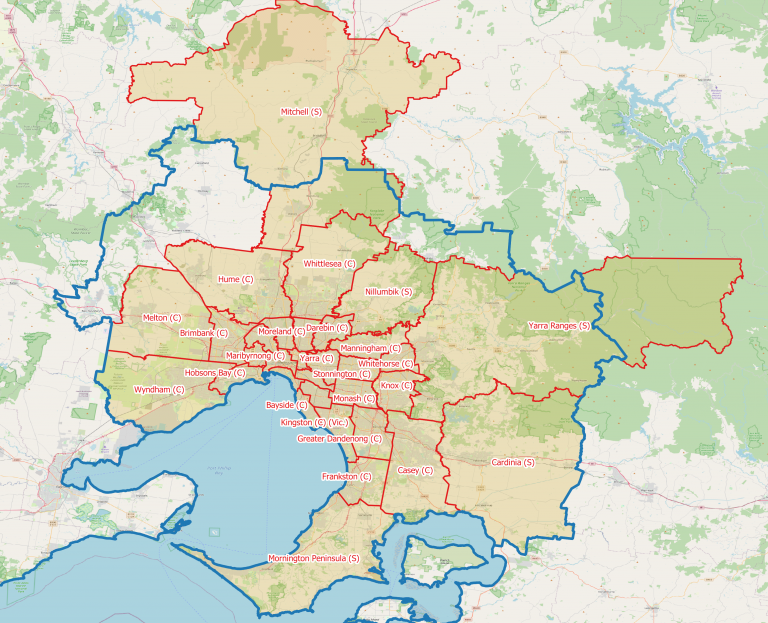
The blue boundary is the Greater Melbourne area, which in 2019 had an Estimated Resident Population of 5,078,193 people. The red boundary is the state government LGA-based definition of Melbourne, plus to the north, Mitchell Shire which is in lockdown. The LGA based definition had 4,999,184 people defined as “Melbourne” and an extra 46,082 in Mitchell Shire.
So the population difference isn’t huge. But there are some differences.
- Though they have been considered part of Greater Melbourne since 2011 by the ABS, the areas of Bacchus Marsh, Gisborne, Romsey and Kinglake escape level 3 restrictions as the State Government’s LGA definition doesn’t consider them part of Greater Melbourne.
- The areas of Mitchell Shire of Wallan, Beveridge and Wandong (large growth areas just north of the urban fringe of Melbourne that are expected to have a population over 80,000 by 2041) are considered by the ABS to be part of Greater Melbourne, but not by the State Government. They are included in the lockdown as the whole of Mitchell Shire has been singled out for restrictions as part of the metropolitan area.
- The northern parts of Mitchell Shire such as Seymour, Broadford and Kilmore are not part of the metropolitan area by any definition, but are in Mitchell Shire and so included in the lockdown.
- The easternmost part of Yarra Ranges Shire, east of Warburton, has a very small population (< 500 people), and isn’t considered part of metropolitan Melbourne by the ABS, but is part of the lockdown.
- The inclusion of Mornington Peninsula seems to be generating the most questioning online. It is part of Greater Melbourne by both definitions and has been for over 30 years. The urban extent of Melbourne is contiguous with much of the population on the western side of the peninsula, with no gap in urban areas between Frankston and Mount Eliza. At the time of writing, there were no known active cases of the coronavirus in Mornington Peninsula Shire – but this is another issue. By any definition it’s part of Melbourne.
- Greater Geelong, on the other side of the bay, is generally considered Regional Victoria by all definitions, and is not currently included in the restrictions.
- These boundaries are both different to the “Significant Urban Area” – which is the built-up extent of the city, and which we use in our top 50 cities blog.
So this all comes back to where you draw the boundaries. The ABS moved away from using Local Government Areas some time ago and now define capital cities by a labour market region – where a large percentage of the workforce work within the urban footprint of the city. But Local Government Areas are easier to work with – they are generally signposted, and most people know which one they live in.
Most of .id’s demographic and economic tools are based on Local Government Areas as these are our clients, and they make evidence-based decisions about the communities within their areas.
But when you start enforcing these boundaries as limits necessary to contain a deadly virus, they move beyond statistics and start impacting people’s lives in a much more direct way. Naturally, people are going to question some of the inclusions!
Glenn Capuano - Census Expert
Glenn is our resident Census expert. After ten years working at the ABS, Glenn's deep knowledge of the Census has been a crucial input in the development of our community profiles. These tools help everyday people uncover the rich and important stories about our communities that are often hidden deep in the Census data. Glenn is also our most prolific blogger - if you're reading this, you've just finished reading one of his blogs. Take a quick look at the front page of our blog and you'll no doubt find more of Glenn's latest work. As a client manager, Glenn travels the country giving sought-after briefings to councils and communities (these are also great opportunities for Glenn to tend to his rankings in Geolocation games such as Munzee and Geocaching).