Bushfires and the Australian demographic landscape
I think everyone has been shocked and saddened by the terrible bushfires we’ve seen around Australia for the past few months, and particularly the horrific conditions in New South Wales, Victoria and South Australia over the Christmas/New Year period. Australia has always been a fire-prone nation, but there is no doubt that climate change is now making our bushfire season longer and more intense than ever before.
Many of the communities we work with at .id have been severely affected by the bushfires, including Bega Valley Shire, Eurobodalla Shire, Shoalhaven City, Wingecarribee Shire, Snowy Valleys Council, Port Macquarie-Hastings, Blue Mountains City, Lithgow City, Clarence Valley Council, Richmond Valley, in New South Wales, Alpine Shire and East Gippsland Shire in Victoria, as well as the Adelaide Hills and RDA Adelaide Hills, Fleurieu and Kangaroo Island in South Australia, and the Shire of Plantagenet in Western Australia (my apologies if I’ve missed anyone – I know fires have been in many, many areas).
Our hearts go out to these areas, for the terrible loss of life, property, wildlife and the environmental toll, as well as the economic toll on local businesses and tourism (Keenan is publishing a piece later this week that looks more closely at the economic impact of natural disasters on local economies).
It will be a long, slow recovery, and we are happy to assist with any data and analysis needs associated with the fire recovery. Often in a disaster situation, there is a need to know exactly who lives in an area, and while much of this is in profile.id, very specific details may be required in some cases (such as understanding how many people with a need for assistance are in a given area, to help plan support services). We are here to help if you’re working with the recovery effort and need this information (contact us here).
These fires have affected a wide range of communities across much of the country, but it’s worth re-reading my blog from 2013, about the demographics of bushfire prone areas. While it’s the Australian bush itself that is particularly fire-prone in times of drought, it’s Aussie’s love of living surrounded by that bush that makes us as communities more fire-prone. And more often than not, the “bush suburbs” surrounding our larger cities and regional towns, as well as places people move to for a “tree-change” are the most fire-prone.
The typical demographic profile of fire-exposed areas
These have a particular age profile – and it’s often mature families with older teenage children who live in them. This is the age profile for Glenbrook, in the lower Blue Mountains on the outskirts of Sydney. At the time of writing, this area has not been heavily affected so far by the fire situation, but its age profile is typical of many fire-prone areas.
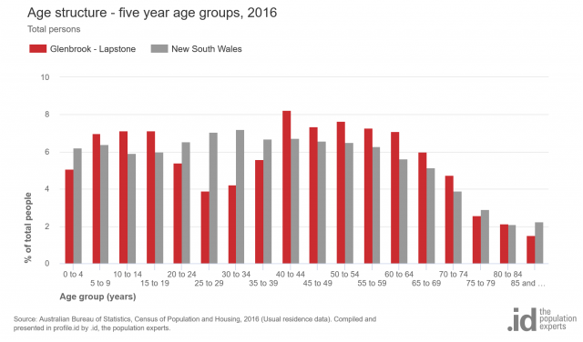

And it is also ageing, with increases in population mainly being in the over 60s groups. Increasingly, with our ageing population generally in Australia, it is also empty nesters and people over the age of 65 whose kids have left home who tend to live in these areas as well.
An older demographic
This does present more of a challenge for fire services in evacuating people who may have more difficulty in travelling. Many of the areas hit in the current crisis have a combination of both the older families and retirement communities, with an average age older than the Australian average. Eurobodalla Shire, on the NSW South Coast, has a median age of 54 which is 16 years higher than the Australian average.
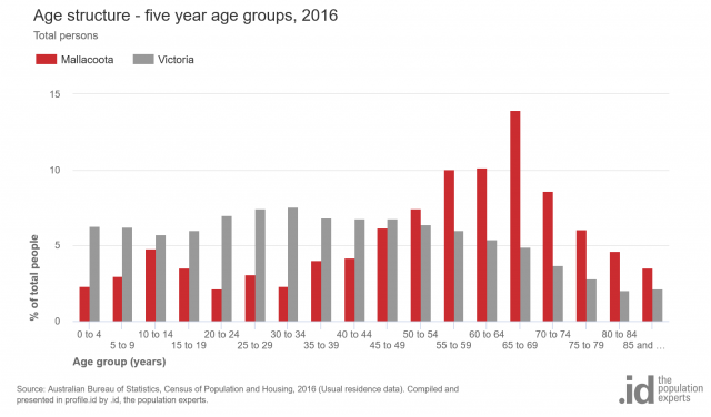
This is the age structure for Mallacoota, one of the worst-hit areas in the current bushfire crisis. You can see that the population is heavily skewed to older age groups, but there is still a small spike in the families with teenage children age groups, despite the relative remoteness of this area.

This type of information can assist fire services and disaster recovery agencies in understanding the people they are dealing with and helping to protect. Unfortunately, it seems likely that serious bushfires are here to stay and becoming more frequent in the Australian environment. Understanding what drives the demographics of people living in areas likely to be subject to bushfire risk is just as important as understanding what drives the bushfires themselves, in helping to combat that risk.
Again, we express our sympathy and strongest support for the fire-ravaged communities, and please let us know if there is anything we can do to help.
Glenn Capuano - Census Expert
Glenn is our resident Census expert. After ten years working at the ABS, Glenn's deep knowledge of the Census has been a crucial input in the development of our community profiles. These tools help everyday people uncover the rich and important stories about our communities that are often hidden deep in the Census data. Glenn is also our most prolific blogger - if you're reading this, you've just finished reading one of his blogs. Take a quick look at the front page of our blog and you'll no doubt find more of Glenn's latest work. As a client manager, Glenn travels the country giving sought-after briefings to councils and communities (these are also great opportunities for Glenn to tend to his rankings in Geolocation games such as Munzee and Geocaching).