Glenn introduces Locality Snapshots – a new feature in our community profiles to give you localised demographic data for small towns that are usually bundled in with larger regional centres.
How can I find a demographic profile for a small town in a regional area?
One of the most common questions our regional clients are asked is “What is the population of (a small town in their area)?”
Until now, demographic data for these small towns have been either
a) incorporated with a larger regional centre, or
b) bundled with other smaller regional communities in the district as ‘everywhere else outside the major centre’
We’ve just released a new feature in our community profiles to make it easier to profile these small towns. Locality snapshots present a demographic profile for these small areas using data from the last Census.
For the 2016 Census version of profile.id, you can now access this full locality list for your area, including basic information on population, dwellings, age structure, employment, birthplace, indigenous status, dwelling structure and incomes. You can find this under the “Specialist Profiles” section of profile.id, under the heading “Locality Snapshots”, for all our rural and regional sites, as well as outer suburban areas with significant rural components.
Data randomisation and small populations
For localities in your area with 50 people or more, you can get the full set of characteristics from the 2016 Census in the Locality snapshots module.
For localities with less than 50 people, we simply provide the number of dwellings, and total population by male and female. When dealing with such small population counts, more detailed demographic data is too affected by the random adjustments made by the ABS to protect the confidentiality of individual respondents.
Open our directory of community profiles to find a locality snapshots for your area.
How have these areas been represented previously?
The areas we use in profile.id have always been a trade-off. We have 6 Census periods worth of data, and quite a lot of detailed information, so in order to fully profile an area we need a minimum population of around 1,000 people, and in rural and regional areas, this often involves aggregating together a lot of different places under one area.
The 2016 Census makes it a bit easier to include information for smaller places, as the ABS now align their boundaries to closely match the official boundaries of a locality – that is – the common address set which defines a place in Australia.
An example: Locality snapshots for Gunnedah, New South Wales
Let’s see how this works for a specific client – Gunnedah, NSW. Now there’s a lot more to Gunnedah than just Gunnedah!
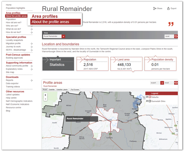
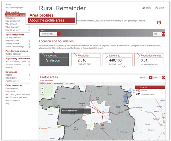
In fact, there are 21 localities of various sizes which are all or partly within the boundary of Gunnedah Shire. In the main part of profile.id, with the long time series (six Census periods), we group most of these into “Rural Remainder”:
Whereas in our new Locality Snapshots menu, you can get information for each of the localities in the area:
Here are the details for the locality of “Blue Vale” (not to be confused with the Blue Whale, the largest animal to have ever lived on earth).

We can see that 61 people were counted in the Census in Blue Vale, in 38 dwellings, and they were mostly older, with about 30% of the population aged over 60.
For smaller localities, like the interesting place called Keepit, only a selection of population figures are available (and they’ve been randomly adjusted to protect individual confidentiality, which is why males and females don’t add to total persons here):

Another great thing about these locality snapshots, is you get to see some of the interesting place names we have around Australia! But most of all, anyone can look up the population of any place through our community profiles.
Changing the old ‘additional areas’ page
Some of our rural clients already had a menu option called “Additional Areas”.
The feedback from our users was that this was a fairly ambiguous name for the module, meaning few people knew what was in there, or how to use it.
‘Additional areas’ contained, in most cases, a list of some of the smaller towns that are now included in Locality snapshots, but using a boundary just for the built-up area (and therefore missing some of the population in the locality just outside the centre). This has been replaced by a standard list, and map with all populated localities in the area – in most cases a much longer list of small towns.
Managing different geographic boundaries
Locality snapshots include data for the whole locality, even where they cross LGA boundaries, as long as some of the population is within the LGA.
So Boggabilla, in Gunnedah Shire, for instance, is included in the list, even though most of it falls outside. This means the total population for all locality snapshots included in the profile for a local government area won’t total to the population of that LGA. And due to the random adjustment and potentially slight differences in boundaries, even where an area in the main “Area Profiles” section has the same name, and boundary, it might not have exactly the same population as the locality snapshots (but should be very close).
These are now available for all our regional and outer metropolitan areas which have smaller localities otherwise combined up to form larger areas in profile.id. For our subscribing councils, there is no increase to existing subscriptions.
If you have found this new feature useful, we would love to hear from you. Share a story about a small town in your area in the comments section below!


