One of the great, nerdy things we do as demographic analysts is to compare how the balance of population changes across a City over time. As part of our recent updates to .id’s Victorian population forecasts, we noticed that the ‘demographic centre’ of Melbourne is shifting – a trend that is set to change even further in the future.
In updating our Victorian Small Area Forecast information (SAFi), we have been analysing growth rates across Melbourne to see the impact that current and anticipated future trends will have on the demographic centre of Melbourne.
Where is the demographic centre of Melbourne?
Most Melburnians recognise the effective centre of Melbourne is the Central Business District (the Hoddle Grid) and its surrounds. The City has been geared towards moving people from the middle and periphery areas to the CBD, with the public transport system, in particular, working to ferry people inwards like the spokes of a wheel towards the hub.
Although this has been the historical focus of employment and key decision-making, growth across and around Melbourne has never been even, with a strong bias towards the eastern suburbs and Mornington Peninsula.
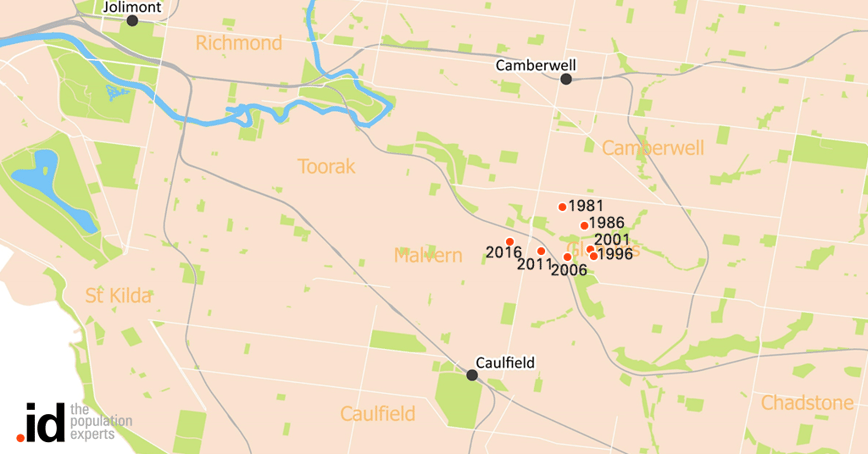
Demographic centre, Melbourne 1981-2016
The map shows the population centroid has been in Glen Iris for many years. From 1981 to 1996, it moved generally in a south-easterly direction, reflecting the comparatively higher share of development in Melbourne’s south-eastern fringe (notably the City of Casey and Mornington Peninsula Shire). By the early 2000s this pattern had changed. Zoned greenfield land in the eastern and south-eastern suburbs was becoming increasingly scarce, as State Government development restrictions in relation to the Dandenong Ranges, Yarra Valley and Mornington Peninsula began to bite.

At the same time, new greenfield offerings in the Western and Northern suburbs (in areas such as Point Cook, Caroline Springs and Craigieburn) helped to shift the balance. In addition, more development was occurring close to the CBD and inner suburbs, which was west and north of the demographic centre.
Where will the centre be in the future?
Since 2001, the demographic centre has been heading in a predominantly westerly and to a lesser degree to the northern direction. With the lion’s share of new greenfield development in Melbourne occurring in the LGAs of Wyndham, Melton, Hume and Whittlesea into the future, this pattern will likely continue to 2041, with the centroid moving into Armadale and finally into Toorak by the mid-2030s.
Demographic centre, Melbourne 1981-2041
.png?width=1024&height=540&name=Centre-of-melbourne-pic%20(1).png)
How the Melbournian culture has changed in the space of a generation or two
People who grow up in Australian cities tend to have great ‘brand loyalty’ and stay in their part of the City, close to friends and family. The inner city of Melbourne has always been a ‘melting pot’, where the rules are less pronounced, but by and large, people have tended to stay in their own sectors.
A big change in Melbourne since the early 2000s has been the impetus for new residential development due to overseas migration (especially tertiary students and skilled migrants). Housing decisions by external migrants are different to locals. In the past, ethnic communities in Melbourne tended to spring up around migrant hostels.
However, the nature of overseas migration has changed with more people moving to Australia as skilled migrants or as students, who tend to make practical and pragmatic housing choices. A look at the background of new development areas in places such as the Cities of Wyndham, Whittlesea or Hume shows a large share of emerging communities in Melbourne, including those from India, the Philippines, Iraq and Sri Lanka.
.id is a team of demographers, population forecasters, spatial planners, urban economists, IT and data experts who use a unique combination of online information applications and consulting services to help governments and organisations understand people and places for evidence-based planning.


.png?width=1024&height=540&name=Centre-of-melbourne-pic%20(1).png)


