BLOG
Standin’ on a corner – are bypassed towns doomed to die?
Standin’ on a corner – are bypassed towns doomed to die?
What happens to towns when they’re bypassed by major highways? Are they doomed, or does it present other opportunities?
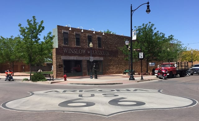
A trip to the US is full of opportunities for pop culture moments, and so it was on a sunny day in May when I found myself standing on a corner in Winslow Arizona. Many readers will be familiar with the song “Take it easy” by The Eagles from the early 1970s, and yes there is a small park there milking the lyric for all its worth. Hence the visit.
So what does this have to do with demographics? Well any visitor to Winslow has to turn off the interstate to visit the town itself. Located about 80km east of Flagstaff, Winslow has not fared so well over the years. Even a cursory drive around town reveals many boarded up shops and homes, and the general feel is one of a dying town. According to the US Census Bureau, Winslow is one of the poorest towns in America – in Australian terms this probably means it has a low SEIFA score.
Winslow – a short history
Of course it hasn’t always been this way – Winslow was originally settled as a railway town and grew to become an important service centre in northern Arizona. Its location on the old route 66 was also strategically important, but with the advent of mass car travel, the railways declined and so too did the fortunes of the town. The town was bypassed by the interstate (I-40) in the late 1970s which of course drew people away from the main street. With all the vacant shops and dwellings, I expected the data to show that Winslow’s population was declining, but there are actually more people living in the town than in the 1970s. However I suspect this due to Arizona State Prison, rather than reflecting actual population increase. In 2015, the population estimate for Winslow was around 9,600 persons, after hovering around the 8,000 mark for most of the 1970s and 1980s.
“Standin’ on a corner” Park in Winslow, Arizona

Bypassed towns on the Hume Freeway – the demographic impact
The Hume Freeway no longer travels through any towns in Victoria, each one having been bypassed at various times over a period of around 50 years. Chiltern was the first town to be bypassed (1962), and Albury-Wodonga the last (2007). Using Census data from profile.id, the table below shows the population of various towns along the Hume Freeway from 1991-2011. The town boundaries in profile.id are stable over the five Censuses to enable time series analysis, and all towns for which we have data are included here.
| Population (enumerated) | |||||||||||
|---|---|---|---|---|---|---|---|---|---|---|---|
| Town/Small Are | Year by passed | 1991 | 1996 | 2001 | 2006 | 2011 | Change 1991-2011 | ||||
| Broadford Area | 1976 | 3,234 | 3,382 | 3,666 | 3,908 | 4,301 | 33.4% | ||||
| Kilmore – Kilmore East | 1976 | 3,280 | 4,124 | 4,801 | 6,135 | 7,210 | 119.8% | ||||
| Seymour | 1982 | 6,880 | 6,589 | 6,765 | 6,231 | 6,282 | -8.7% | ||||
| Benalla | 1987 | 8,275 | 8,519 | 8,556 | 8,532 | 8,635 | 4.3% | ||||
| Wangaratta | 1994 | 16,406 | 15,990 | 16,619 | 16,852 | 17,491 | 6.6% | ||||
| Wodonga | 2007 | 26,579 | 28,546 | 30,338 | 31,528 | 33,817 | 27.2% | ||||
Source: profile.id (Shire of Mitchell, Shire of Benalla, Wangaratta Rural City and Wodonga Rural City), bypass dates sourced from Wikipedia, which summarises the bypass and duplication work.
Clearly, most towns included in this table have grown steadily between 1991 and 2011. The stand out example is Kilmore-Kilmore East, which has doubled in population since 1991. In contrast, Seymour has declined in population since 1991, and particularly since 2001. Regional towns such as Wangaratta and Benalla have recorded modest growth since 1991.
Unfortunately profile.id does not have data for smaller towns along the Hume Freeway. Some information is available through Towns in Time, a Census data product prepared by the Victorian Dept of Environment, Land, Water and Planning. However, readers should not that the boundaries are not necessarily comparable between 2006 and 2011, making time series analysis more difficult. Again, the data shows considerable variation in the demographic fortunes of towns. Avenel has grown steadily since 1991, but its larger neighbour, Euroa, has declined slightly in population since 2001 – after being bypassed in 1992. Small communities such as Tallarook and Glenrowan have recorded some population decline since 1991, but Springhurst and Barnawartha (near Wodonga) have had relatively stable populations over much of this time period.
From the evidence presented here it’s difficult to attribute population change to the impacts of a Hume bypass. Kilmore’s growth has been particularly strong since 2001, and this is largely due to the expansion of the town to the west and south east, with new estates offering relatively affordable housing solutions, but still within the commuting belt of Melbourne. Kilmore is still located on the Northern Highway, offering an alternate route to Bendigo, as well as other parts of northern Victoria. There are other attractors such as major schools and recreation facilities. Consider the growth of Kilmore compared to Broadford just 15 minutes up the road (and bypassed at the same time) – Broadford’s growth has been far more modest.
Seymour’s fortunes have probably less to do with the bypass, rather there are a mix of factors that have contributed to population decline. The town was bypassed in the early 1980s but more rapid population decline did not occur until the 1990s. Interestingly, like Winslow, Seymour’s early growth was attributable to its location on the railway, but it too has suffered as employment in this industry sector has declined over the decades. More importantly, Seymour’s fortunes are closely linked to the nearby army base at Puckapunyal, so changes to employment and on site residents at the base have an impact on the town itself. Compared to other parts of Mitchell Shire, the demographic fortunes of Seymour are influenced by a lack of demand for new housing. Data from successive Censuses also shows that there is a strong out flow of young adults, so the population is ageing. While this situation is not unique to Seymour, it is more characteristic of dryland farming towns rather than towns that are within Melbourne’s wider economic catchment.
The population data from the Census indicates a mixed impact on bypassed towns. It would appear that a complex set of factors, including geography, population size and industry mix, explain the demographic fortunes of towns after they have been bypassed. The most extreme example of population decline amongst the Hume Highway towns is Seymour, and this is largely attributable to the industry mix and the decline of employment in railways rather than the actual bypassing of the town. The fortunes of towns that have declined in population may have in fact been set in stone before the bypass, rather than actually occurring as a result. The experience of bypassed towns generally is expressed through economic terms, whereas some towns may actually benefit from being bypassed, as they become destinations rather than a place name on a freeway offramp. Evidence from Winslow shows that the opening of the Standin’ on a corner Park has once again attracted visitors to the town centre – certainly the two recent visitors from Australia weren’t the only ones taking the obligatory photos on that sunny day in May!
.id is a team of population experts, who use a unique combination of online tools and consulting to help organisations decide where and when to locate their facilities and services, to meet the needs of changing populations. Access our free demographic resources here.
Simone - Myth Buster
Simone has a rich background in human geography, demography and urban planning – a background that was useful in her previous roles in the Commonwealth and State Governments, and now as part of the forecast team at .id. From the Queensland coast to the southern suburbs of Perth, Simone produces population and dwelling forecasts that help local governments make informed decisions about future service and planning needs. She is a regular contributor to .id’s blog and has spoken at several conferences on how our cities and regions are changing. She is a big advocate of evidence-based planning and how Census and other data can inform this. Outside of work Simone is a keen traveller and photographer – interests that tie in well with her professional life and help her to understand “place”.


