Population growth in Western Australia
This blog has been superseded and we have now updated our population forecasts for Western Australia. Read more here.
We’ve all heard about the mining boom in Western Australia, but what has been the impact on population growth and change? Since 2007, WA has been the fastest growing State or Territory in Australia, and in the last few years the volume of growth has almost outstripped that of Queensland. In the period 2012-13, Western Australia’s population increased by 3.3%, or 81,300 persons. It also reached the minor population milestone of 2.5 million persons. This rapid growth is mainly a result of increased net migration, both from interstate and overseas. It goes without saying that rapid population growth creates challenges for urban and service planning, but let’s take a look at the evidence base and what is happening at smaller geographic scales.
The settlement pattern
Australia’s largest state has a distinctive settlement pattern and its climate and topography vary widely. Much of the inland is not favourable to human settlement. Greater Perth is home to around 80% of the State’s population, and in fact around 90% of the WA population live in Perth and the south west of the State. Apart from Perth, there are a lack of large towns – Mandurah might be considered a separate city but it is increasing part of the greater Perth area. The largest towns (Signficant Urban Areas as defined by the ABS) outside of greater Perth are Bunbury and Geraldton.
Which areas grew the fastest?
Each year the ABS releases population estimates (the ERP) for local government areas (LGAs). The map below shows the percentage change in population over the period 2012-13. The darkest shades of blue show LGAs with the highest rates of growth, while those shaded red indicate population decline. Clearly, the highest growth rates were concentrated in the greater Perth area, the south west coast and part of the north. The fastest growing LGA was Derby-Kimberley (6.9%), located in the north east, followed by Boyup Brook Shire (6.4%), located in the south west between Perth and Albany. It should be noted that both of these LGAs have small populations so despite the large percentage increase, the volumes in both cases were quite small (652 and 105 persons respectively).
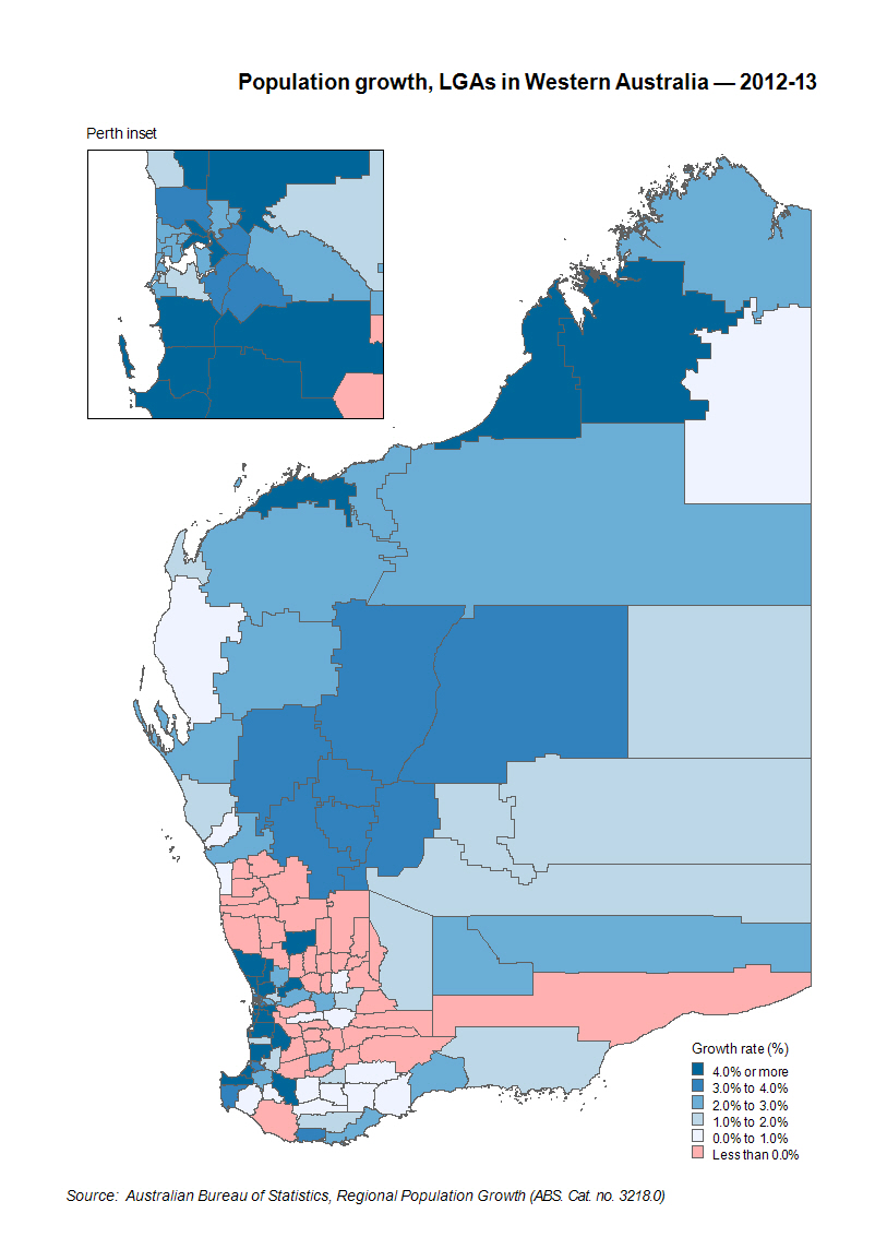
All LGAs in the greater Perth region recorded population growth in 2012-13. Much of outer northern and southern Perth recorded very high rates of growth ie over 4%. Most notable were Serpentine-Jarrahdale (6.1%), Armadale (6.0%) and Kwinana (5.8%) in the south, and Wanneroo in the north (5.0%). Wanneroo holds the distinction of recording the highest volume of growth of any WA council in the 2012-13 period (8,630 persons). Growth in all these LGAs is driven by rapid development of greenfield estates on the urban fringe. Typically their occupants will be young families, and couples yet to have children, who are first home buyers. The larger size of family households is part of the dynamic contributing to high levels of population growth in these areas.
As with other major Australian cities the inner areas continue to grow strongly as a result of the construction of high density apartments which typically are popular with young adults seeking rental accommodation in close proximity to employment or education. The City of Perth, neighbouring Vincent, and Victoria Park across the Swan River, all grew by more than 4%. The City of Perth in particular has some very large residential projects in the pipeline which will add substantially to the dwelling stock in the next few years eg Elizabeth Quay.
The end of the mining boom?
Though several commentators suggest the mining boom has ended, this tends to refer more to the industry moving from a construction to operational phase and consequent the lower employment requirements. But the demographic impacts are still apparent. Across the north there is rapid population growth. Derby-Kimberley may have grown by almost 7% in 2012-13, but Broome (5.2%) and Roebourne (since renamed Karratha – 4.7%) also grew strongly. Much of this growth is related to the mining operations and the increased demand for services and infrastructure in the larger towns – after all, even FIFO workers need to buy food at some stage, or even have the aircraft in which they fly serviced by an engineer, or attended to by flight crew. In other words, there is some inbuilt momentum for service related population growth.
A resurgence in gold mining operations are also an important driver for a cluster of small inland councils in the middle of the WA desert that recorded growth of more than 3%, but this should be treated with caution as many inland WA councils have very small populations ie less than 1,000 persons in most cases. The most extreme example is the addition of 4 persons to the populations of both Murchison and Sandstone which represents growth of more than 3%, but their populations in 2013 were around 120! Many of these councils were initially established during the gold rush period in the late 19th century and had substantial populations at the time, but demographic processes of out-migration have taken their toll on population levels since.
Peri-urban/semi-rural areas
Of particular note is the number of peri-urban councils that recorded high growth rates in the 2012-13 period. Though these councils have small populations, generally they are well integrated into the greater Perth area and some have small towns around which urban development has occurred in recent years. North of Perth, Chittering, Gin Gin and Northam all grew by more than 5%, as did Murray in the south. Improving transport links, whether they be roads or rail, have major impacts on peri-urban areas as it increases access both economically and socially. For example, the opening of the Perth-Mandurah train line, coupled with extensions and upgrades to the Kwinana Freeway has spurred development south of Perth, reducing the travel time for commuters and businesses alike.
Areas of population decline
The map shows that there were LGAs in WA that recorded population decline in 2012-13 and these tended to be concentrated in the inland agricultural areas particularly to the north and east of Perth. However once again it needs to be stressed that these are small councils and most cases the population loss amounts to less than 20 persons. Westonia Shire, located about 300kms east of Perth, recorded the largest percentage loss of population (-3.2%) but this amounted to just 9 persons. Neighbouring Merredin Shire recorded the largest volume of population loss but this comprised just 60 persons. Population loss from agricultural areas is a long standing demographic trend in Australia and is associated with population ageing and out migration of young adults.
What’s next?
The ABS release population data for States and Territories on a quarterly basis and these show that while population growth in Western Australia remains high, it has slowed marginally, with a rate of 2.9% recorded for the year ended December 2013. The next available data for LGAs will be released in April 2015.
However if you don’t want to wait, and you want our view on how the population will change in future, we have just completed state-wide small area forecasts (SAFi) for WA. you can find out more about them here and even come to our launch on October 22nd in Perth.
Read more in our new eBook, Western Australia: Is it all doom and gloom after the boom?

Simone - Myth Buster
Simone has a rich background in human geography, demography and urban planning – a background that was useful in her previous roles in the Commonwealth and State Governments, and now as part of the forecast team at .id. From the Queensland coast to the southern suburbs of Perth, Simone produces population and dwelling forecasts that help local governments make informed decisions about future service and planning needs. She is a regular contributor to .id’s blog and has spoken at several conferences on how our cities and regions are changing. She is a big advocate of evidence-based planning and how Census and other data can inform this. Outside of work Simone is a keen traveller and photographer – interests that tie in well with her professional life and help her to understand “place”.