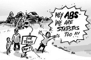
Well, according to this article and a report on one of those 6:30pm shows on the telly, that’s what the good citizens of Taradale, Victoria decided to do, when the ABS apparently no longer had stats for their town’s population. But did they? And why would a town just drop off the map?

The ABS has always recognised and drawn boundaries around, towns with more than 200 population at Census time. With the change to the new geographic standard in 2011, the rules have been made a bit stricter about which areas will have a boundary drawn around their town area, which is what enables data users to get a town population.
Taradale is a picturesque little village exactly 100km north west of Melbourne, just south of Castlemaine. It used to be on the main highway between Melbourne and Bendigo, but was bypassed a few years ago, and now it seems the townspeople think the ABS has bypassed them too!
In fact, for the last few Censuses, going back as far as 1991, I can find no time when Taradale was in the “official” locality in the ABS list. In 2006, the reason was that only 199 people were counted in the boundary of the town which was used at the time – yes, it missed out by 1! This referred to the “urban” population, just a small distance around the town centre (a pub and a general store). For 2011, along with a number of other very small towns, the ABS has not drawn a boundary around the Taradale township, so a comparable population for 2011 can’t be derived, and even if it did make 200 for the town population, it wouldn’t be counted as an urban centre or locality.
So, despite there really being no change in the standard output from the ABS between 2006 and 2011, the people of Taradale are a bit upset about this, and have decided to leave Australia and form their own country. While we think this may be slight over-reaction, at least under the previous model, you could get data from 2006 for the town boundary as it used to be (presumably at some stage in the past the town population was over 200 and the ABS up to 2006 had kept the boundary.)
The good news is that .id is here to help.
Both .id’s community profile, and the ABS website both have data for Taradale in 2011, just based on a slightly different boundary.
Mount Alexander Shire, the LGA in which Taradale lies, is a subscriber to profile.id, and we have just launched our new “Summary profiles”. These give you a lot of information on smaller towns – not just their population, but a wealth of Census characteristics on age, households, religion, income, education etc, with comparisons to 4 standard benchmarks.
So Taradalites, you can rejoin the nation! The boundary we are using is the same as the ABS does now, and we actually think it’s a more logical and useful boundary. It is larger than the previous one, and covers the whole locality – that is, the whole area within which people have a right to use the address “Taradale”. We use these boundaries a lot in our community profiles because they tend to form logical communities of interest and people identify with them.
This is also a great example of why it’s very difficult to compare data from the ABS over time – The previous boundary they used for Taradale as a suburb was the old town boundary and excluded the rural population. It now includes that population, so it looks like the population has doubled. That’s why .id does a lot of work to concord the boundaries over time and make them comparable.
So here is the population data for Taradale (you will need to select the town from the drop-down list once you get to this page) – in 2011 there were 463 people living there. Yes this boundary is wider, but our best estimate, using mesh-blocks is that only 117 people live in the “built up” area – which is really just a few houses along the main road and a couple of offshoots (yes, you can build up almost any area from mesh blocks in the 2011 Census, but is this the most useful population to know?). The 2006 town boundary used by the ABS (remember it wasn’t even an official locality then) probably overestimated this figure, but underestimated the whole locality population by not going out to the official gazetted boundary.
Most of the population live in the semi-rural surrounds. Being within commuting distance of both Melbourne and Bendigo and having plenty of land around it, Taradale attracts families who want to live on large blocks, with room for the kids to play. This is reflected in the relatively high proportion of teenagers, and their parents in their 40s and 50s. There are also quite a few empty nesters – retirees looking for the quiet life.
So when you look at Census data, always check what boundary you’re looking at – we have the boundaries for our summary profiles right on the page, and they are interactive Google Maps images so you can check and see exactly what the area looks like in real life as well – even streetview!
Don’t forget to check out the summary profiles for towns in your own area – all live on profile.id right now! Most local government areas with a rural component have summary profiles available, for all the little towns which are otherwise included in larger districts on the profile.
And Taradale – please come back to Australia, we miss you!
Access the Australian Community Profile now! You will find Census results for each Capital City, State, Southeast Queensland and Australia on topics including population, age, country of birth, languages spoken, occupations, industries, employment, disability, income, qualifications, transport and much more…
Access the new profile.id sites and other population statistics for Local Government Areas and suburbs at .id’s demographic resource centre.


