Can the history of Rockingham help us understand the future?
It might seem obvious but one of the more intriguing aspects of population forecasting is the numbers. The size of the populations that are forecast at future points in time can either be scary, or represent a challenge.
From the perspective of 2015, it’s difficult to envisage how are cities will look when they have much larger populations. Population projections produced by the ABS indicate that Sydney and Melbourne will reach 6 million people by 2036, and Perth around 3.5 million. But what will this mean for our way of life? Where will these additional people live? How will they get around? Perhaps we can look to the past to understand just how much change our cities have seen in a relatively short space of time.
At .id we have an enviable collection of old street directories and they are fascinating for showing how our cities have changed over the decades.
Recently I completed a forecast for the City of Rockingham in Perth’s southern suburbs. It’s typical of outer suburban areas around Australia in that it has experienced significant outward expansion of its built up area.
The population, particularly in the Baldivis corridor, is growing rapidly. However it also has older established areas that have stable or even declining populations. In other words, it’s a diverse area demographically and this partly reflects its development over a number of decades.
I dusted off the old Perth street directories in .id’s collection and was fascinated to see in the 1974 edition of the Perth UBD, Rockingham as we know it in 2015 barely existed. In fact, it was known as the Shire of Rockingham and the suburb of Warnbro represented the limit of maps! Judging from the street pattern, there was a built up area along the Rockingham foreshore and Shoalwater, but Safety Bay was largely undeveloped, and Cooloongup was just a place name.
By 1985 things had changed dramatically, as shown below. About half the streets in Cooloongup and Waikiki existed and the remainder were planned. Of note is the high school site in Waikiki – in 2015 this is now being developed as housing (but I don’t believe it was ever developed as a high school). The limit of maps in 1985 was still Warnbro, but there was an inset showing the beginning of development in Secret Harbour – an area now nearing its completion.
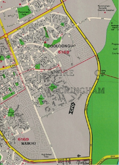
Source: UBD Street Directory, Perth, 28th edition (1985)
By the 1994 edition, Cooloongup’s street pattern looks much like it does in 2015, and Port Kennedy shows the first signs of rapid development. The 1994 edition shows detailed maps all the way down to Mandurah, but the former seaside villages of Golden Bay and Singelton are separate settlements accessed only from the Mandurah Road – the full length of Warnbro Sound Avenue had yet to be completed.
The population of Rockingham is forecast to reach 196,312 in 2036. This is a significant increase on the 2011 population of 109,415. There is still a significant supply of residential land in Rockingham and the City will continue to attract young families seeking relatively affordable home owning opportunities. The current focus of urban development is the Baldivis corridor and it will remain so for the foreseeable future. Our forecasts assume more than 20,000 new dwellings in Baldivis over the forecast period. However development fronts in Karnup will become more important over time, particularly when necessary transport infrastructure is upgraded. Other areas such as Golden Bay will see their greenfield land supply exhausted in the next decade or so and as their populations mature over time, ie following the suburb life cycle.
But while most suburbs in Rockingham will continue to grow, others have exhausted their supply of greenfield land, and with limited opportunities for redevelopment, their populations will remain stable or decline. As described above, Cooloongup grew steadily throughout the 1980s and 1990s, when young families moved into the suburb – much as they are now doing in Baldivis and Golden Bay. Cooloongup’s population, reached a peak in the late 1990s, but since the 2001 Census it has declined as the children of the families have matured and moved out to form their own households elsewhere. The major change in household types since 2001 has been a decline in family households with children, and an increase in lone person households.
But while Rockingham’s population will be approaching 200,000 in the late 2030s, let’s put this change in perspective. In 1986, the population was just 32,845 and in the twenty five years to 2011 it trebled in size (I’m assuming no change in geographic boundaries). Rockingham added more than 76,570 people to its population over that time, and in the next twenty five years is assumed to add another 87,000.
Certainly population growth brings about its planning challenges – but these are not new. In the case of Rockingham, rapid population growth has been the norm for a number of decades. Their planners are aware of these challenges and demographic tools such as forecast.id enable them to plan effectively for the future.
Australian cities will continue to grow and change over the coming decades. This is inevitable, but it always has been. The components of demographic change, and the way they operate in Australia determines this. We have high levels of net overseas migration, and there continues to be more births than deaths. The 2036 numbers for Sydney and Melbourne in particular seem unimaginable in 2015, but the same could be said for population forecasts completed in the past – I’m more than certain that when population forecasts of 4 million were made for these cities back in the past, these numbers, and their implications for metropolitan planning, seemed unimaginable.
What’s important is that the numbers are used for effective forward planning and that the how and why of population change is understood. Of course whether or not we’ve done this in the past is open for debate, and another blog (or two, or three….).
Simone - Myth Buster
Simone has a rich background in human geography, demography and urban planning – a background that was useful in her previous roles in the Commonwealth and State Governments, and now as part of the forecast team at .id. From the Queensland coast to the southern suburbs of Perth, Simone produces population and dwelling forecasts that help local governments make informed decisions about future service and planning needs. She is a regular contributor to .id’s blog and has spoken at several conferences on how our cities and regions are changing. She is a big advocate of evidence-based planning and how Census and other data can inform this. Outside of work Simone is a keen traveller and photographer – interests that tie in well with her professional life and help her to understand “place”.