Pinpointing vulnerable communities for emergency management
We’ve brought forward the publication of this blog in light of the recent developments with Covid-19 in Australia, as we know many councils and community groups are planning ways they can respond and support vulnerable communities in their area.
This work was originally developed to support preparation for natural disasters such as Cyclones, however many of the principles apply to the Covid-19 pandemic (for example, identifying elderly communities), and provides useful guidance on how to use your social atlas tool to identify these groups in your area.
If this blog and your social atlas don’t provide the level of detail you need, contact our demographic consultants here to discuss a more in-depth or customised analysis of your area.
I recently had the privilege of speaking in Far North Queensland on using the .id toolkit for emergency management. Cairns turned on one of its hottest days of the year (38 degrees, 80% humidity) for a packed room of staff involved in emergency management and disaster recovery across the region.
We have recently done some work for a few Queensland councils on pinpointing the locations of people who would be vulnerable in the event of an emergency situation. In Queensland, this is most commonly a cyclone, but the idea could be used for bushfires, floods, earthquakes, and even virus outbreaks like the Covid-19 pandemic.
There are certain communities which are generally likely to be more vulnerable and difficult to access in emergency events. We have worked with councils to refine a list of these groups, many of which you can pinpoint using .id’s social atlas tool – others are available along with analysis of their distribution via a consultancy with .id.
What makes communities vulnerable?
The things which make communities vulnerable fall mainly into two categories
- People who may be difficult to reach to communicate with and therefore unaware of the situation.
- People with poor mobility or community connectedness, who may not be easily able to escape a situation and need help doing so.
We workshopped a few of these groups in consultation with our council partners. This is not an exhaustive list but highlights the sort of detailed information you can map from the Census to get a handle on the groups you need to involve in disaster management.
- Homeless population (absolute and relative)
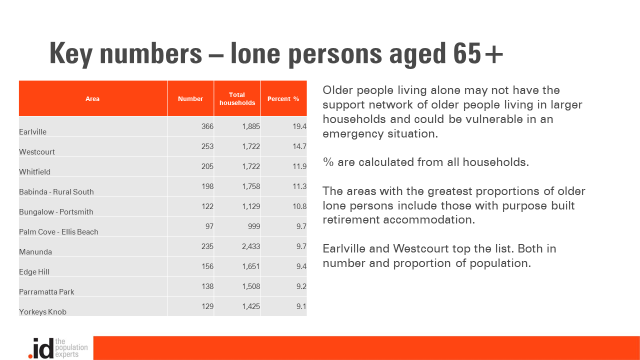
- People aged 65+ (seniors)
- Lone person households (people living alone)
- Lone person households aged 65+
- People with a disability
- Disengaged youth (15-24 year olds neither in education nor employment)
- People in low-income households (bottom 25% of Australian incomes)
- People with poor English proficiency
- People with no internet access at home
- People with no motor vehicles at the household
Most of these can be easily pinpointed using .id’s atlas tool, where councils subscribe to this. Here are a few examples from Cairns.
The homeless population
This is probably one of the most vulnerable groups of all. Homeless counts from 2016 Census are included as part of profile.id, in the population highlights page
In Cairns, the greatest number of homeless were counted in the central areas of the city, including Cairns City (469 people), Manunda (200) and Westcourt (99).
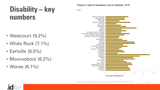
People with a disability
People in need of assistance due to a severe or profound disability may have both communication issues and mobility issues in an emergency management situation, and are likely to need assistance to evacuate.
The Census collects this information, though it is a known undercount. Mapping via atlas.id can help, along with some disability modelling we do to estimate current and future numbers of different disability types using the Survey of Disability, Ageing and Carers. Here are the details for the Cairns region.
Lone person households aged 65+
This is a larger group and may need further refinement. Older people living alone may be vulnerable from both a communication and a mobility perspective. In Cairns, as in many places, these are strongly associated with areas that have a lot of smaller housing stock, and retirement villages.
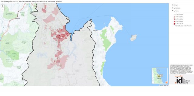
Poor English proficiency
This group is likely to have communication difficulties in that they may not be aware of or able to read warning preparation messages. It’s also possible that the support networks in the community for those with poor English proficiency may be patchy. Not a huge group in Cairns, they make up about 2% of the total population. However, it’s easy to narrow this down to specific language groups as well.
In Cairns, over 60% of those with poor English proficiency speak just 5 languages – Japanese, Nepali, Korean, Mandarin and Hmong (all Asian languages and representing a recent wave of migration to the area).
The council have recently done some work in this area, and published cyclone preparedness brochures in Nepali, which I was able to look at (not to read, however, as I am not fluent in Nepali!).
Visitors to the area
This is a really key group in Cairns, which may or may not be so important in other areas.
Visitors may not be familiar with the area, not know the channels to get warning messages and may or may not have access to transport.
Cairns is a huge tourist destination. Almost 29,000 people in Cairns Regional Council on Census night were not at home. This is about 17% of all the people counted in Cairns on Census night. 10,000 of these were overseas visitors.
Further analysis can be done on this community to see where they come from and where they are staying. But it should be noted that Census is a snapshot for a Tuesday night in August which is peak tourist season for this area (and not for others, eg. in Southern Australia), but not peak Cyclone season for the area.
More detailed communities
Further analysis can pinpoint extremely vulnerable communities. These are not currently in atlas.id but can be accessed via a consultancy with .id – Other combinations of cross-tabulated variables can really help look at very localised concentrations of disadvantaged groups.
- People with poor English proficiency and no internet at home
- People with poor English proficiency, no internet at home and no motor vehicles
- Lone person households aged 65+ with no internet and no motor vehicles
- People with a disability in low income households.
- Visitors to the area not at their usual address on Census night.
You can access a lot of this information at a very fine detailed level if your council subscribes to our social atlases (atlas.id). The .id toolkit is a fantastic resource for looking at those communities which are likely to be vulnerable in an emergency situation, and Cairns are making good use of this right now. If you don’t have atlas at your council, or are interested in any further analysis of these populations as a report or presentation, contact our demographic consulting team here to discuss your project.
Glenn Capuano - Census Expert
Glenn is our resident Census expert. After ten years working at the ABS, Glenn's deep knowledge of the Census has been a crucial input in the development of our community profiles. These tools help everyday people uncover the rich and important stories about our communities that are often hidden deep in the Census data. Glenn is also our most prolific blogger - if you're reading this, you've just finished reading one of his blogs. Take a quick look at the front page of our blog and you'll no doubt find more of Glenn's latest work. As a client manager, Glenn travels the country giving sought-after briefings to councils and communities (these are also great opportunities for Glenn to tend to his rankings in Geolocation games such as Munzee and Geocaching).