The new ABS geography standard part 1 – what is it and how does it affect me?
Over the past few years, the Australian Bureau of Statistics has been working out a whole new Statistical Geography for Australia.
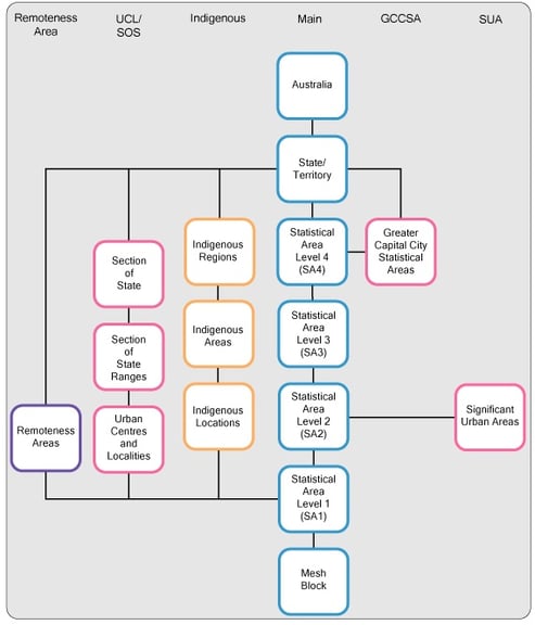
![]()
Now Statistical Geography may not sound like the most interesting topic, unless you work here at .id in which case it’s fascinating! It underpins most of the data that you can get from the Census, and most of our work at .id, as well as a whole lot of other ABS collections. ABS is moving to a completely new set of areas for the release of data, which will change what data is available for what areas.
- There will be a completely new structure of the geographic areas on which all statistics (not just Census) are collected by the ABS.
- Local Government Areas are no longer a core part of the structure and need to be built as a “best fit”.
- There will be more data available for smaller regions within heavily populated areas.
- There will be less data available for sparsely populated areas – eg. very small towns under 200 people.
- The definition of capital cities is changing.
For .id clients, .id will do all the work in making sure that geography is consistent over time for our clients. However there are some things you do need to know about the new geograpy. This is the start of a series of articles looking at the new geography and how it affects you.
The current ABS geography
What you may not know is that the ABS puts a lot of effort into defining the areas for which it collects data. There is in fact a whole department of the ABS bureaucracy dedicated to just maintaining geographical standards! They define geographic areas as a hierarchy, going from the whole of Australia, down through states, regions, right to the individual Census Collection Districts (in 2006 and earlier years).
For the past 30 years or so you’ve had a hierarchy of areas, which goes like this:
- Australia
- States/Territories
- Statistical Divisions (SD)
- Statistical Subdivisions (SSD)
- Local Government Areas (LGA)
- Statistical Local Areas (SLA)
- Census Collection Districts (CCD)
Our community profile users are somewhat insulated from this complex geography (our areas are mainly defined based on talking to Local Government about communities that “make sense” on the ground). But you can still see some of the ABS units in there. The most common one is the “Statistical Division”, which is a broad region within a state, or a whole greater capital city area. We usually use this as a benchmark for capital city LGAs to make comparisons to the region in which they operate. For some examples, see:
Strathfield Council (benchmarked to Sydney SD)
Knox City (benchmarked to Melbourne SD)
Joondalup City (benchmarked to Perth SD)
Griffith City (benchmarked to Murumbidgee SD)
The new ABS geography
From the 2011 Census this is all changing (though the old units will be available for this Census only as a crossover). The new geographic units will be:
- Australia
- States/Territories
- Greater Capital Cities
- SA4
- SA3
- SA2
- SA1
- Mesh blocks
Capital city regions are likely to change under the new structure and we will cover this in detail in a later article.
Note that in the new hierarchy, there is no mention of Local Government Areas, they sit off to the side, rather than in the current geography where they are the basis for defining the “Statistical Local Area” .
Why is it changing?
The haphazard nature of Statistical Local Areas and their relationship to LGAs is one of the reasons for the change. In many parts of Australia, 1 LGA = 1 SLA, but in some areas such as Brisbane and Canberra, LGAs are split into SLAs that comprise individual suburbs. In others, such as Sydney and Melbourne, the larger LGAs are split into 2 or 3 parts, while the smaller ones are SLAs in their own right. This is because these breakups evolved over time as the ABS added new areas, or local governments amalgamated.
This is one of the reasons the new geography is being introduced, wholesale, all at once – to make everything consistent again.
The other reason is that consistency over time is considered paramount – it’s no good having data collected on different geographic areas in different time periods, because you can’t compare them. That’s why at .id we put so much effort into making our geography consistent, so you can compare over time. Unfortunately, with LGA based units, ABS have to change the boundaries every time there is a Local Government amalgamation or boundary change.
So the ABS is introducing the “Australian Statistical Geography Standard”, primarily so that they don’t have to change areas in between Censuses at all, and don’t have to align to LGA and other administrative boundaries.
What does this mean for local government?
What they are doing is moving Local Government off to one side, and defining areas based on their own understanding of “functional boundaries”, which might be logical barriers such as rivers and roads, or the economic zone of a town. This doesn’t necessarily have anything to do with a local government area, and yes, some of the newly defined areas do actually cross LGA boundaries.
ABS have promised that, from Census at least, you will still get LGA totals, but the difficult thing is that you used to be able to get a nice neat progression, adding up all the Collection Districts and SLAs in your area to an LGA total – this will no longer apply.
Another confusing element of the new geography is that areas of the same name won’t necessarily relate to the same area – eg. There is a large area in the new geography which will be called “Yarra Ranges”. This will be approximately the same as, but not quite – the LGA of Yarra Ranges Shire, with some minor boundary adjustments.
No need to worry
Of course at .id, we will take care of all of these issues for our local government clients, so that your community profile and other Census based information products will be delivered for a geography that represents your communities. Most importantly we will make sure that the geography is consistent right through from the 1991 Census to the 2011 Census.
So while there are some downsides to the new geography, .id will make sure they don’t matter too much to our clients. And there are some significant positives in the new areas as well.
What are the benefits?
For the first time, there will be consistency across Australia in the non-Census collections. Eg. in most Australian metropolitan areas, you will be able to get population estimates each year for SA2s, which replace SLAs, and are roughly equivalent to suburbs in many cases (more on these in another article). Not just population estimates but anything else which is currently produced for SLAs, such as Building data, Tourist Accommodation, Births and Deaths, should be available on the new geography.
This is a much better resolution than what was available before. Just as an example, the City of Blacktown, the largest LGA in NSW, currently consists of 3 SLAs, so you can get detailed non-Census data (population, building etc.) for those 3 areas. Under the new geography, there are 17 areas within Blacktown with this data available, so it is much more detailed. Again – the catch is that the 17 areas don’t add up to the LGA exactly, but include tiny parts of neighbouring councils, along suburb and functional area lines.
Again, don’t worry too much about the details, if you have profile.id or forecast.id, we’ll be doing all the legwork in making sure your geographic areas are consistent over time.
Find out more
Part 2: Introducing the SA1, your new Collection District
Part 3: Replacing SLAs with SA2s
Part 4: Understanding the new ABS Geography part 4. SA3s and SA4s
Part 5: New ABS Geography part 5: Greater Capital Cities – are they greater?
Here are some links to the new geographic areas on the ABS website:
The Australian Statistical Geography Standard – 1270.0.55.001 – released on December 23rd last year, to give everyone a chance to read it over the Christmas break!
Outcomes of the discussion paper in 2008 outlining the need for a new geography.
.id is a team of demographers, population forecasters, spatial planners, urban economists, and data experts who use a unique combination of online tools and consulting to help governments and organisations understand their local areas. Access our free demographic resources here
Glenn - The Census Expert
Glenn is our resident Census expert. After ten years working at the ABS, Glenn's deep knowledge of the Census has been a crucial input in the development of our community profiles. These tools help everyday people uncover the rich and important stories about our communities that are often hidden deep in the Census data. Glenn is also our most prolific blogger - if you're reading this, you've just finished reading one of his blogs. Take a quick look at the front page of our blog and you'll no doubt find more of Glenn's latest work. As a client manager, Glenn travels the country giving sought-after briefings to councils and communities (these are also great opportunities for Glenn to tend to his rankings in Geolocation games such as Munzee and Geocaching).